
Zhejiang Linhai National Geopark is located in the coastal zone about 50 kilometers east of Linhai City in the eastern part of Zhejiang Province. The park is located on the east side of Wenzhou Zhenhai Great Fault. GeoPark is characterized by the Late Cretaceous volcanic intrusive eruption rock formation that formed about 95 to 65 million years ago in China.
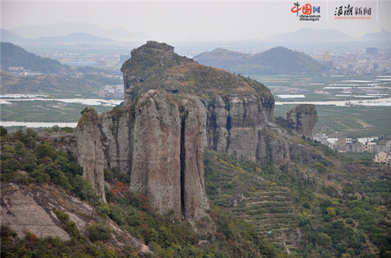
The main strata of the geopark is the Upper Cretaceous Tiantai Group, which is part of the late Mesozoic volcanic eruption belt along the eastern coast of Zhejiang. Volcanic activity is dominated by eruptions of acidic magmatic eruptions. Inside the geopark is the unique lava platform, peak plexus, and stone forest formed by layered volcanic rocks, fault structures, and vertical columnar joints. These are the main elements that constitute the natural landscape of the park. The highest peak in the park is Baiyan Mountain, which is 508 meters above sea level, while the general peak is 200-300 meters above sea level.
The Dakantou volcanic intrusive rock (rheumatic crushed lava) is located in the vicinity of Dakantou Village in eastern Panpan. The crater area is about 2 square kilometers. The central part of the volcanic crater is formed by late acid lava intrusion and forms a volcanic igneous structure, and about 15 million stone pillars resulting in lava cooling. Stone pillars and hexagons are very regular geometric shapes, like artificial carvings. Stone pillars are vertically extended 300-500 meters in height and exposed, arranged in an orderly or erect or reclining position. They are layered and magnificent. They are magnificent and magnificent. They can be described as million pillars of stone forest. In addition, Wanzhu Peak, Qianzhu Cliff, fence wall, giant road, and coral rock, the majestic spectacular stone landscape, and various waterfalls and streams constitute a natural picture, which makes people feel relaxed and happy.

There is also a large number of flow structures formed by the overflow of acid lava. They are horizontally and erectly distributed, and the thickness of flow marks is common. There are also tower-shaped rock peaks formed by volcanic channels (consisting of the natural three-towers of Taozhu). The rock towers are cliff and plain in top. They are 150-200 meters above the surrounding mountains. They are located in the coastal area and are particularly spectacular. Such as "castle", "screening" , "Hibiscus", is a good place to watch the sunrise and misty sea. The acidic lava platform undergoes structural uplift, weathering and erosion, and seawater erosion to form peak column topography and sea erosion cave topography. (Promotion)
來源: 中國網 | 作者:俞霄 | 責編:李佩 審核:張淵
![]() 新聞投稿:184042016@qq.com 新聞熱線:13157110107
新聞投稿:184042016@qq.com 新聞熱線:13157110107


中央機構 | 人大機構 | 國家主席 | 國務院 | 人民法院 | 人民檢察院 | 政協機構 | 民主黨派 | 群眾團體 | 駐外機構 | 站長統計
中國網際網路視聽節目服務自律公約 | 網路110報警服務 | 12321垃圾資訊舉報中心 | 中國新聞網站聯盟 | 人員查詢
版權所有 中國網際網路新聞中心 電話: 13157110107 京ICP證 040089號
網路傳播視聽節目許可證號:0105123 京公網安備110108006329號 京網文[2011]0252-085號
關於我們 | 法律顧問:京衡律師事務所 | 刊登廣告 | 聯繫方式 | 本站地圖 | 違法和不良資訊舉報電話:010-88828271 88828235 | 對外服務:訪談 直播 展會 廣告


版權所有 中國網際網路新聞中心
電話: 057187567897 京ICP證 040089號


 浪潮評論
浪潮評論 潮評社
潮評社 國網傳播
國網傳播 微店
微店
 忠文創
忠文創